Going mapless for a change
In the few short years in which I’ve owned a smartphone, mapping apps have already meddled with the way I deal with unfamiliar cities, turning me into a twitching screen-neurotic at every intersection. “Move fast and break things” indeed: like my natural sense of direction, for example. Graçias, Silicon Valley! But disruption also brings opportunities to inspect the mess left behind. First though, a little resistence.
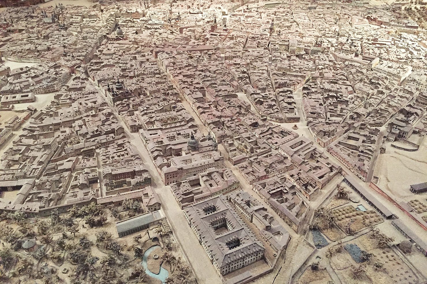
I grab a printed map for tourists from a glass info-pod on Placo del Prado. The map is the size of a fast-food place mat, printed on absorbent stock and framed by snack coupons. Notable buildings are picked-out as line drawings, penned with a jaunty disregard for aerial perspective, and street names – typeset in sizes practical for those suffering from eye injuries – render the map as a cobweb of typography rather than as a spatial diagram. The city itself, its network of streets and its blocks of buildings, retreats behind the black lace of letterforms. I find the importance of these jumbled labels strange, as if streets were termini rather than a medium for passage. The map is useless, a boneyard of proper nouns. It might conceivably be of help in wordless communication with bespectacled taxi drivers, or as a McGuffin in some geospatial comedy of errors. Or as a supersized coupon for discount churros. So for the moment I’m back to compulsive phone jerking.
Filtering gestures
I was in Madrid, walking obsessively, and thinking a lot about maps, memory and space, as walking is wont to make me do. Digital cartography, and specifically Google Maps, have introduced multiple novel dimensions to mapping: public participation, data aggregation, modularity; and more visibly, fluid scaling and the superimposition of near real-time information, affected by the now ubiquitous pinched zoom. Our real-world gesture for estimating the size of anything smaller than, say, a potato, is now relayed to a map via thumb and forefinger, manipulating its scale relative to the screen. Seven pinches take you from kerbside to continent. A single lazy swipe banishes 120° of longitude from the screen. The illusion instilled in ours minds is this: that all of our planetary spatial knowledge can be tucked away in a pocket close to your buttocks.
The pinching gesture reveals or obscures layers of information, based on a clandestine system of relevance-grading defined by Google’s engineers, interface designers and cartographers. As a response to the challenge of diagramming physical space at all useful scales, it’s pretty clever, but is perhaps more susceptible to questions of hegemony and authority than those posed by fixed-scale paper maps. The pinched-zoom has made the political trappings of mapping more legible, turning them into a palpable expression of the medium’s operability. Whilst de-cluttering screen real-estate is standard practice in GUI design, the dynamics of adjusting a map’s scale on the fly exposes the extent to which scale is a medium for context, and that those who define the context control knowledge.
In his paper “Google Maps as Cartographic Infrastructure” [1], Jean-Christophe Plantin, Assistant Professor in the Department of Media and Communications at the LSE, offers a stern reminder. Google, he writes, “can decide what needs to be included or excluded from the cartographic representation, who determines society’s spatial representation, and what form and shape public participation will take.”
Who broke my contiguity?
In June 2018 an annoying feature was added to Google’s mapping app. On launch, a tab swoops up from the bottom of the screen and implores me to “Explore Embajadores”. My options are limited. “Restaurants”, “Bars” and “Attractions” are on offer, with “More” stashed behind an ellipsis. The city comes pre-chewed, and neatly regurgitated as a convenient array of services. In a typical Silicon Valley oxymoron, “exploration” is hoodwinked into meaning scrolling through a taxonomy of aggregated shopping and dining options.
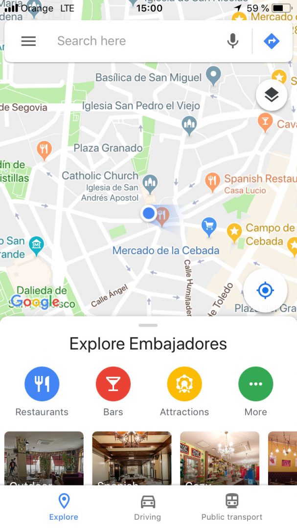
More obviously irritating is that a third of the map is now temporarily obscured by a chum box of relevancy-spam. (Disappointingly, the word “relevant” has its roots in the medieval Latin for “raising up”: sadly it seems that pop-ups are relevant by etymological default.) As an incorrigible app-closer and re-opener, I’m forever swatting away this interruption when checking my location.
Exploration presupposes being lost. Google’s map sucks the potential for serendipitous encounter from physical space: the unquantifiable and unclassifiable is weeded out, since its business model is based on quantifying everything. One thing is clear: I am not being invited to explore Embajadores, but signalled that Google is exploring me in Embajadores.
Maybe all I really want is the map’s little blue dot with its panoramic gaze. A technological answer would be to introduce discrete modes: one for serendipitous wandering and one for goal-oriented consumption. A more sane response would be to ditch the phone altogether and reinstate trust in environmental cues.
A pathology of lostness
When mapless in cities, and weather permitting, I try to keep rough bearings by tracking the sun and divining the fall of shadows. Madrid is obliging in this matter. For the walker, the topography of Europe’s highest capital is conveniently legible. The city was built on a plateaux adjacent to the Manzanares river. If you’re going uphill, you’re heading towards El Centro; if you’re going downhill, you’re headed out towards las afueras. General clues, available to any urban walker, keep me roughly informed. Street-width, traffic density, people’s clothing and movement, the types of shops, building height, patterns of litter; all serve to build up a socio-economic model of place.
The paper map forced me to think in terms of street names, but whilst strolling they play a lesser and rather duplicitous role in navigation. With their deep ties to local history they are allusive, even though their inherent literalness makes them as digestible as a witty remark or a passing factoid. I am as amused by Plaza de Jesús as I am bemused by Pasadizio del Panecillo. Street signs in Madrid, though, have a little more to offer. Many take the form of an illustrated three-by-three grid of ceramic tiles.
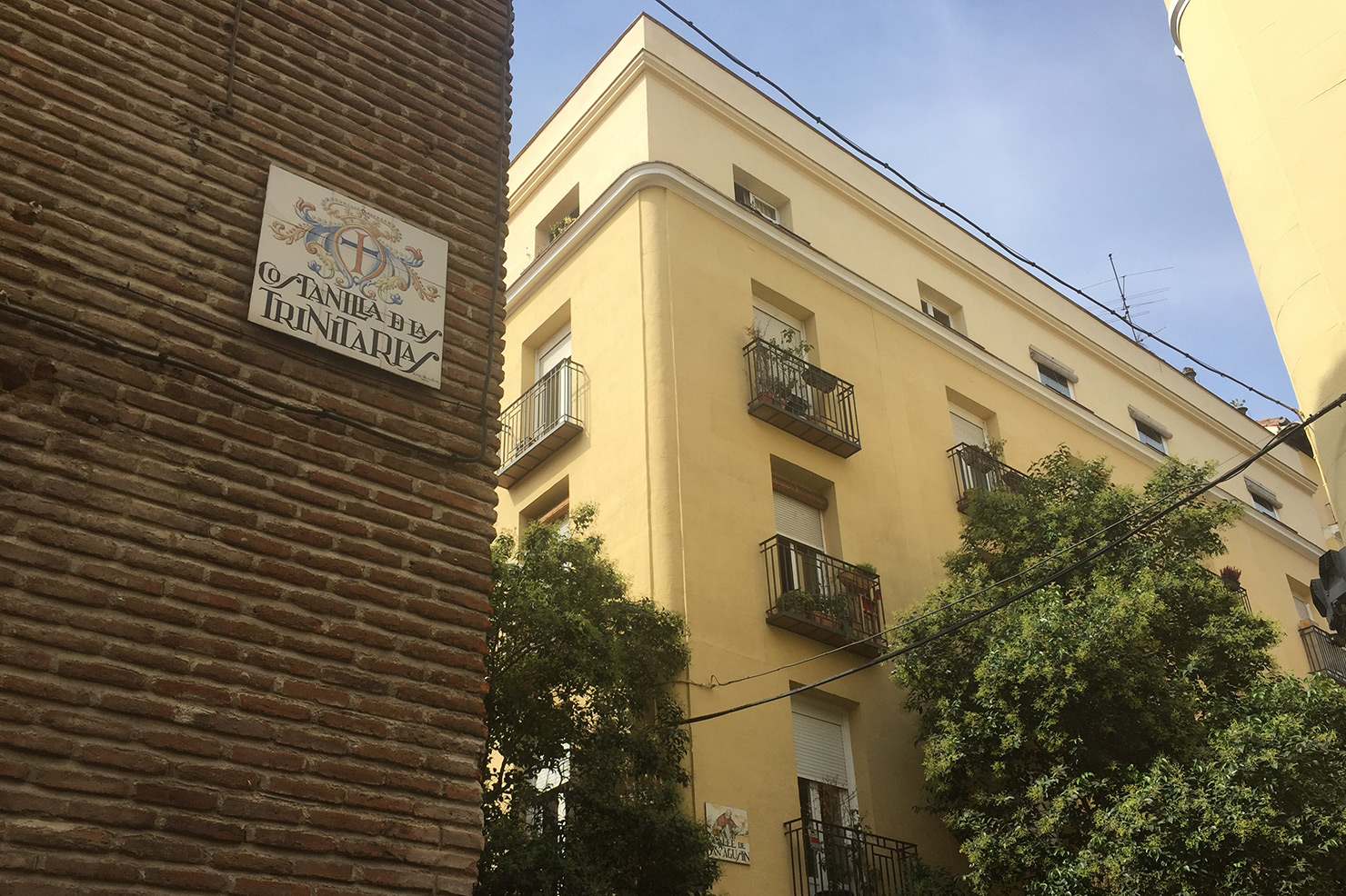
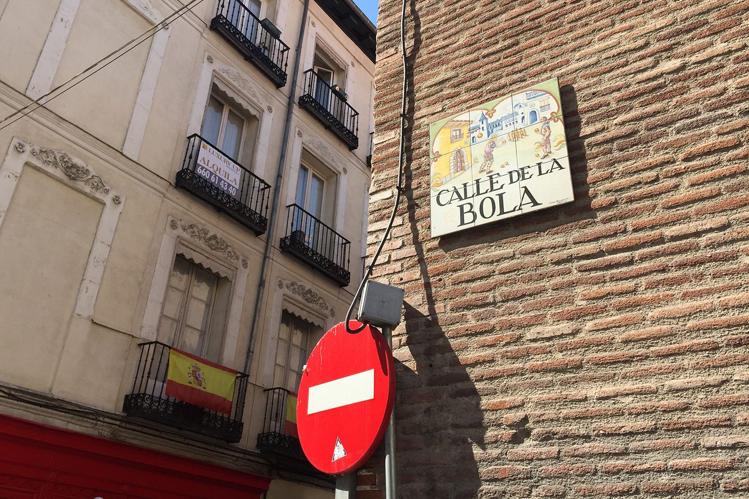
Somewhere close to the Opera (a reconstruction of that day’s meander points to the corner of Calle de Independencia and Calle de la Amnistia), two of these signs are blanked out. Where a charming display of hand-lettering and deft brush strokes ought be, nine spotless white tiles cling to the façade. On an adjacent street it’s the same. With maps on my mind I feel primed to find significance here. A smaller sign at shoulder height invites me to contemplate:
“Can you imagine not remembering the name of this street? Do you not know where you are?”
Indeed, I can relate. But I wonder for a moment if the enquiry is of metaphysical nature. Context follows:
“Today we leave the streets blank to remind ourselves of the importance of identifying the early symptoms of Alzheimer’s, and also showing our commitment to those who invest in this disease and help to make it a memory of the past.”
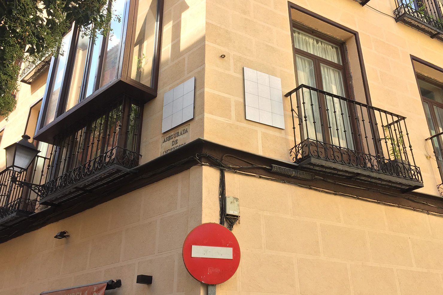
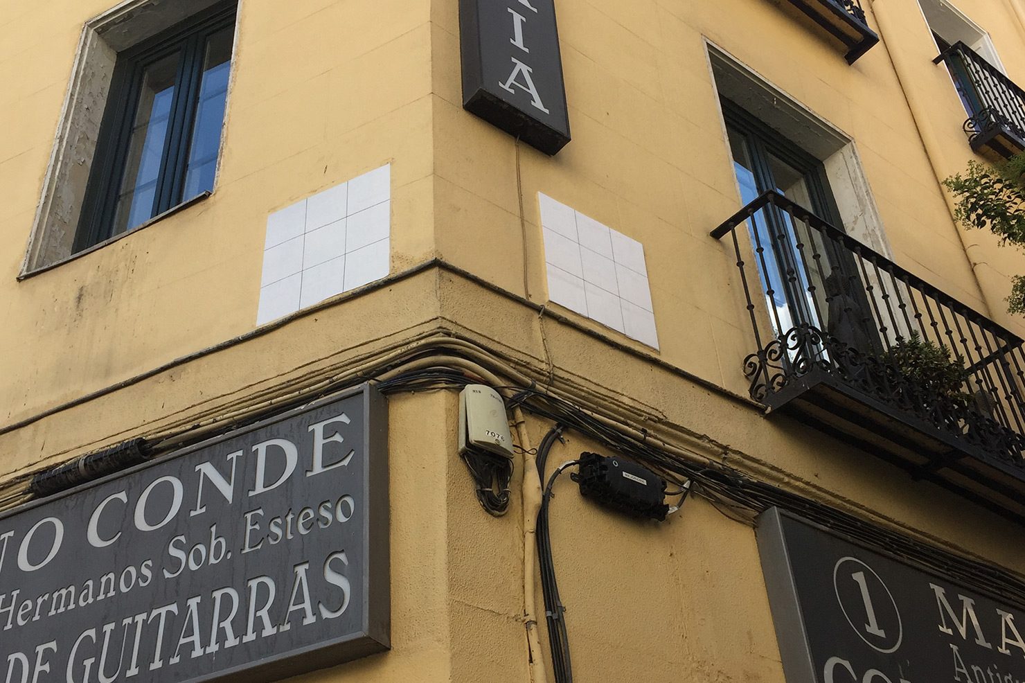
The hijacking of Madrid’s odonyms to mark International Alzheimer’s Day is part of the initiative #CallesEnBlanco, originally devised in the city of Barcelona by the ad agency Ogilvy for the La Caixa Foundation. Alzheimer’s ranks as a dread-disease: the gradual obliteration of “self” defines its nightmarish trajectory. Synaptic and neuronal depletion in the cerebral cortex and subcortical areas of the brain are its hallmarks. Short-term memory loss, difficulties in performing routine tasks, problems interpreting images, and temporal and spatial disorientation rank amongst its symptoms.
It’s a cynical thought, but the symptoms map all too readily onto the behavioural patterns associated with being constantly online. Conversations interrupted by Wikipedia fact-diving; articles frantically sought to validate arguments; phone twitching on street corners; aimless app-switching; half-remembered news stories; selfie-cides … The operational logic of Google’s map, specifically, might be regarded as a weak simulation of Alzheimer’s symptoms, a strategy enabling it to simultaneously masquerade as a cure. Pathologise lostness and monetise spatial knowledge
The thrust of this techno-scepticism feels familiar, but is not entirely unwarranted. Nicolas Carr’s essay “Is Google Making us Stupid?”, published in The Atlantic a decade ago, posited that the way we read is being altered by the Internet; that attention spans are being reduced, and that the perceived efficiency and immediacy of skim-reading is fundamentally changing the way we think. The backlash to Carr’s article coincided with social-media boosterism, with one dissenting voice accusing Carr of missing “the humanising impact of Web 2.0”, an idea entirely lost to the wind in 2018.
But the backbone of Carr’s argument was an acknowledgement of the brain’s inherent plasticity, its ability to re-wire itself in new situations, as the swollen hippocampi of London’s taxi drivers attest [2]. The four-year training London’s cabbies undergo, known simply as The Knowledge, requires them to memorise upwards of 25,000 streets and several thousand points-of-interest. The discovery is part of a host of recent research into the relationship between memory formation and spatial orientation.
In a review of Luke Dittrich’s story of an amnesic known to medical science as ‘Patient H.M.’, Israel Rosenfield and Edward Ziff of the New York Review of Books note:
“It is becoming increasingly clear that human and animal memory depend on the ability of the hippocampus to establish relations between an individual and his or her surroundings.” [3]
It was John O’Keefe and Jonathon Dostrovsky’s 1971 discovery of place cells within the hippocampus (which fire when an animal enters a particular environment), that showed that memory processing and spatial processing were related [4]. More spectacularly, Edvard and May-Britt Moser’s 2014 discovery of grid cells (which fire regularly in clusters arranged on a triangular grid), showed that the brain is able to form a cognitive representation of Euclidean space [5].
Just as we discover that orientation and memory formation are entwined – part of our hardware – we are refining the tools which threaten to unravel them. When GPS chips are routinely implanted in our brains (and everything suggests someone will try), we can expect the hippocampus to wither, and the ability to process memories and chart time’s arrow to dwindle.
Chart me a narrative
I’ve long been baffled and intrigued by my own capacity to recall memories only when a location is brought to mind. My wife will say, “Can you remember when we met [such and such] for dinner last June?”, and I will stare blank-faced into the middle distance until a brief description of the restaurant’s interior is provided. A moment in time is recollected around a seed of space. Similarly I have no problem recognising the topography of someone’s face after years of absence, but am prone to forget people’s names the instant they are introduced. Hence, I have committed none of Madrid’s street names to memory, but have no problem locating on a map the streets whose physical properties I’ve internalised.
I’ve long been grasping after a deeper understanding of how personal and collective memory can be read from and written into the spaces we inhabit. Maurice Halbwuchs’ 1950 treaty La Mémoire collective describes how collective memory is dependent on “frameworks” within which particular groups are situated in society. Google’s map feels like a distraction, a proxy framework. Its alchemistic transmutation of public participation into corporate profits exploits the collective. It’s jurisdiction over spatial knowledge, captured in a bell jar of permanent nowness (always on, always up-to-date), is antithetical to memory. It’s a dark contraption that makes a tool of its user.
Perhaps then, as place cells and grids cells imply, the act of walking itself comes closest to the kind of cognition I’m looking for. As though motion were a branch of thinking. Missing from digital maps are narratives and the temporal. Memories are the residue of time’s passage, and time’s passage calibrates our traversal of space. Space is time, thickened. Aimless walks – alone, or in company – are an antidote to the pathology of lostness, the loss of time, and subscriptions to proxy frameworks. Shared time and space. Mapless. Without objectives. Open to impulse, suspicious of plans. Half recalled, half forgotten. ▲
[1] Jean-Christophe Plantin, “Google Maps as Cartographic Infrastructure: From Participatory Mapmaking to Database Maintenance”, International Journal of Communication 12 (2018), 489–506
http://eprints.lse.ac.uk/84243/
[2] Katherine Woollett, Hugo J. Spiers, Eleanor A. Maguire, “Talent in the taxi: a model system for exploring expertise”
http://rstb.royalsocietypublishing.org/content/364/1522/1407.figures-only
[3] Israel Rosenfield and Edward Ziff, “Making Memories”, New York Review of Books, Volume 63, Number 13, review of “Patient H.M.: A Story of Memory, Madness, and Family Secrets”, by Luke Dittrich.
https://www.nybooks.com/articles/2017/08/17/making-memories-patient-hm/
[4] G. W. Humphreys, J. Duncan, A. Treisman, John O’Keefe, Neil Burgess, James G. Donnett, Kathryn J. Jeffery, and Eleanor A. Maguire, “Place cells, navigational accuracy, and the human hippocampus”, Philosophical Transactions of the Royal Society of London. Series B: Biological Sciences
http://doi.org/10.1098/rstb.1998.0287
[5] Hafting, T.; Fyhn, M.; Molden, S.; Moser, M. -B.; Moser, E. I. (2005). “Microstructure of a spatial map in the entocrinal cortex”. Nature.
https://doi.org/10.1038/nature03721