Playful Noticing: Exploring an Unremembered Diagonal
Noticing
I’ve lived in the same neighbourhood of Berlin for close to twenty years; enough time for the steady ebb and flow of daily routine to deposit a plaque on the senses, dulling them to the superabundance of detail and idiosyncrasy so characteristic of the place I call home. Over-familiarity with a place can sometimes feel like its opposite: as though the constantly expanding index of things newly noticed throws a veil over the enduring features to which one is well accustomed.
For the most part, this process of noticing and un-noticing takes place without one even, well … noticing. So it’s difficult to know precisely why two particular features of my immediate environment should have suddenly volunteered themselves for more scrutiny in 2019. I’d long registered both details separately, but hadn’t given them much thought. Both involve subtly anomalous diagonals embedded in the fabric of the neighbourhood which are formed by the shape and arrangement of buildings close to what was once one of Berlin’s southern city gates, Hallesches Tor. As I studied them, I came to see how both were related to each other, and how they tell a quiet and enduring story of a city’s expansion.
Bisecting
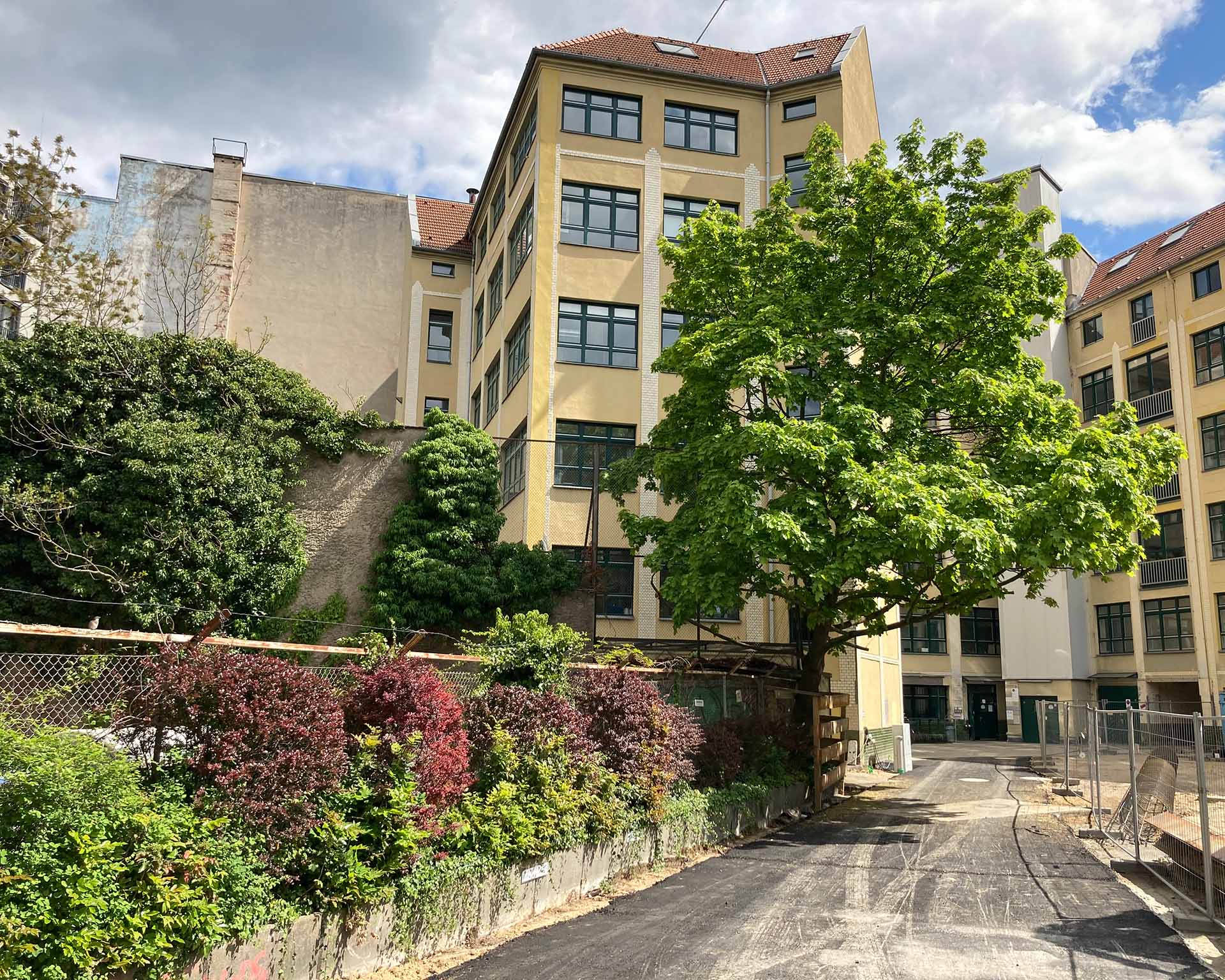
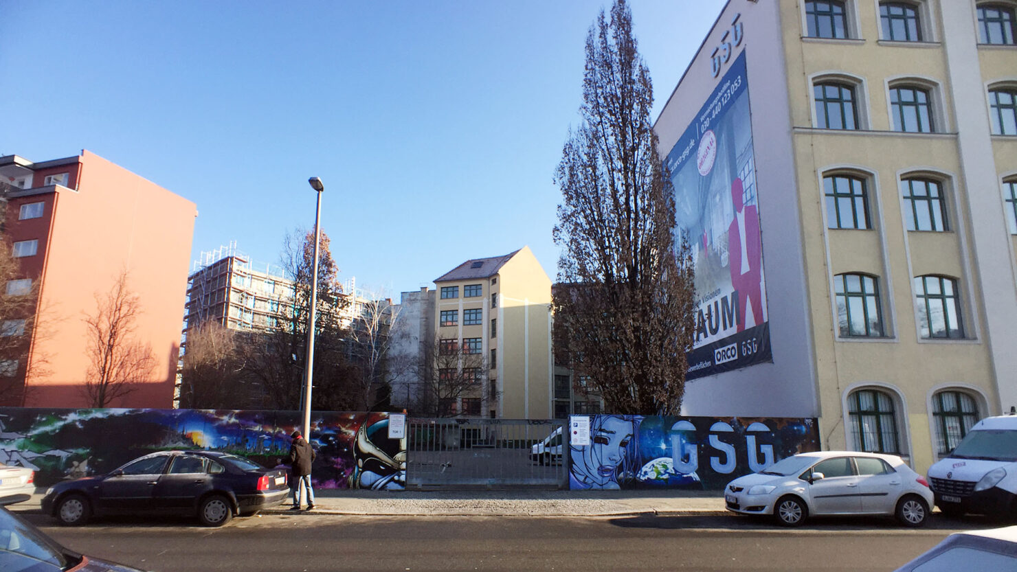
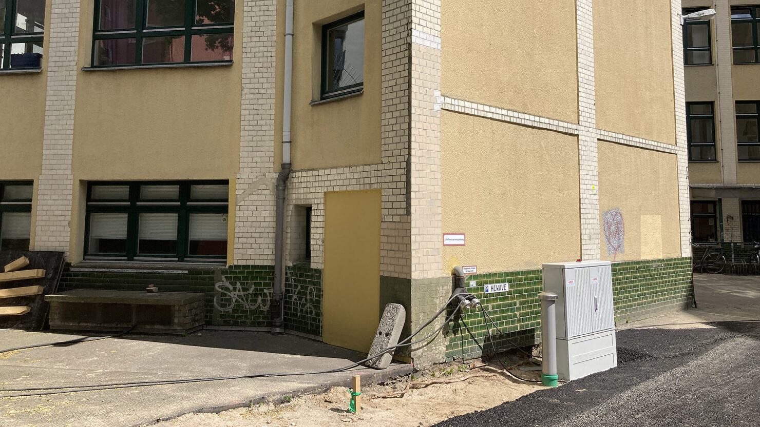
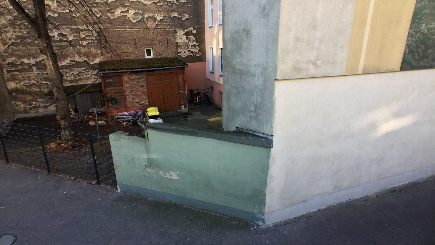
The first feature is the windowless exterior wall of a building which is set back from Zossener Straße behind what has long been a parking lot. As of spring 2022, the space is a construction site.
The wall forms the broader side of a shallow volume which protrudes from its host building at an angle of 45°. A stump, a stunted outgrowth of brick which cannot conceivably house anything more than a staircase.
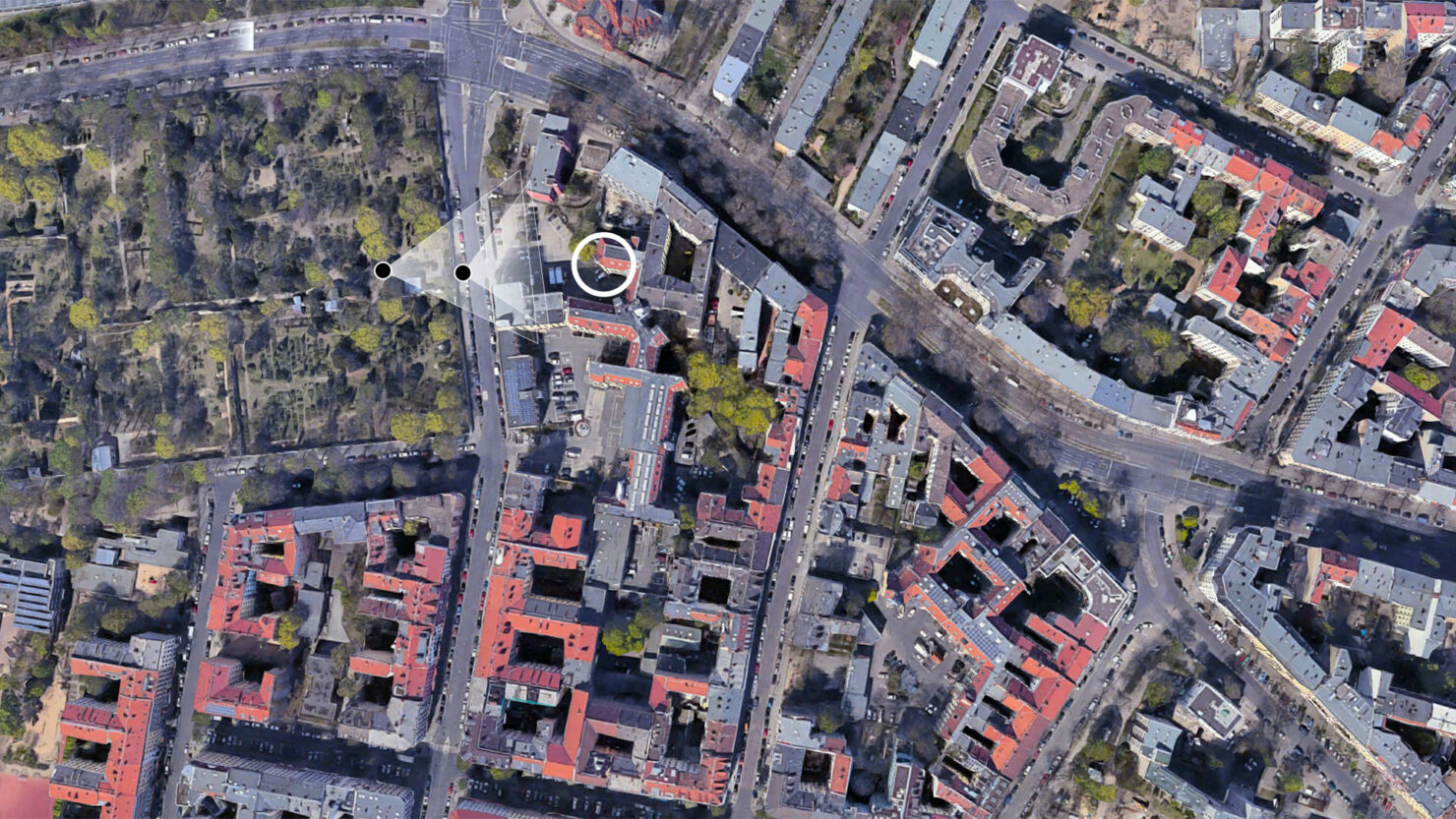
In some respects, this particular feature is typical for Berlin, where spatial anomalies and structural inconsistencies can often be traced back to the havoc of World War II. The wall is visible from the street only because of the parking lot between the two, which probably owes its existence to an allied bomb having obliterated the structure which once stood there. Before the war, the wall would have been partially concealed within the city block. Senate archives make verification possible:
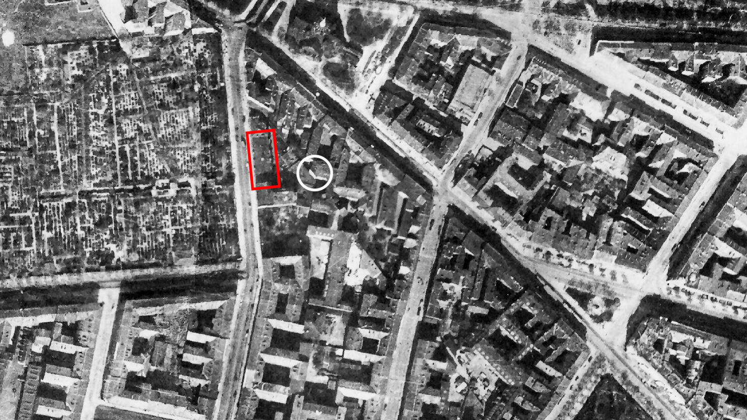
An aerial photograph from 1928 shows the building which once stood here, and judging by the fall of shadow onto it, the building which had once concealed the wall from the street was probably only one or two floors high. Our wall is circled white, and appears bright in the midday sun. So whilst the question of its current visibility from the street can be accounted for by wartime destruction, two things remain a bit odd.
Firstly, the wall does not connect with a neighboring structure as might be expected of a windowless façade deep within a densely built city block. The 1928 image is difficult to interpret, but it does appear that a low structure of perhaps just one floor was built adjacent to it, though not up its entire height. The building can’t have been much more than 30 years old when this photo was taken, so we can assume that most of the wall was exposed since its construction. But it still looks as if it should have been a firewall between adjacent buildings.
Secondly, and more peculiar still, is its oblique orientation to the surrounding roads. It doesn’t align with the north-south axis of Zossener Straße, nor to the NW-to-SE axis of Blücherstraße to the north. Instead, it seems to bisect the two angles formed by those streets. Ghost geometry. As though the wall were silently poised to fulfill some forgotten contract, which is now suffused within the brickwork. A vestige of circumstances long forgotten by the modern disposition of streets.
Uncovering
Once I’d noticed the diagonal wall, I decided it needed closer investigation, both on the ground and on maps. Further scrutinising aerial photos on Google Maps, it quickly became apparent that the diagonal can be traced further back into adjacent courtyards to the south-east. Directly behind where it is visible from Zossener Straße, the same angle traverses three more properties with addresses on Blücherstraße (to the north), and one more on Mittenwalder Straße (to the east). Aerial views are obscured by the boughs of trees, because Google tends to use satellite images taken during the summer months. Using Mapbox Studio I edited a figure-ground plan, and coloured red all the buildings affected by the diagonal. This revealed that the line actually continues all the way through Mittenwalder Straße, which runs parallel to Zossener, then slips invisibly across the road and makes a final appearance within the courtyards behind Schleiermacherstraße.
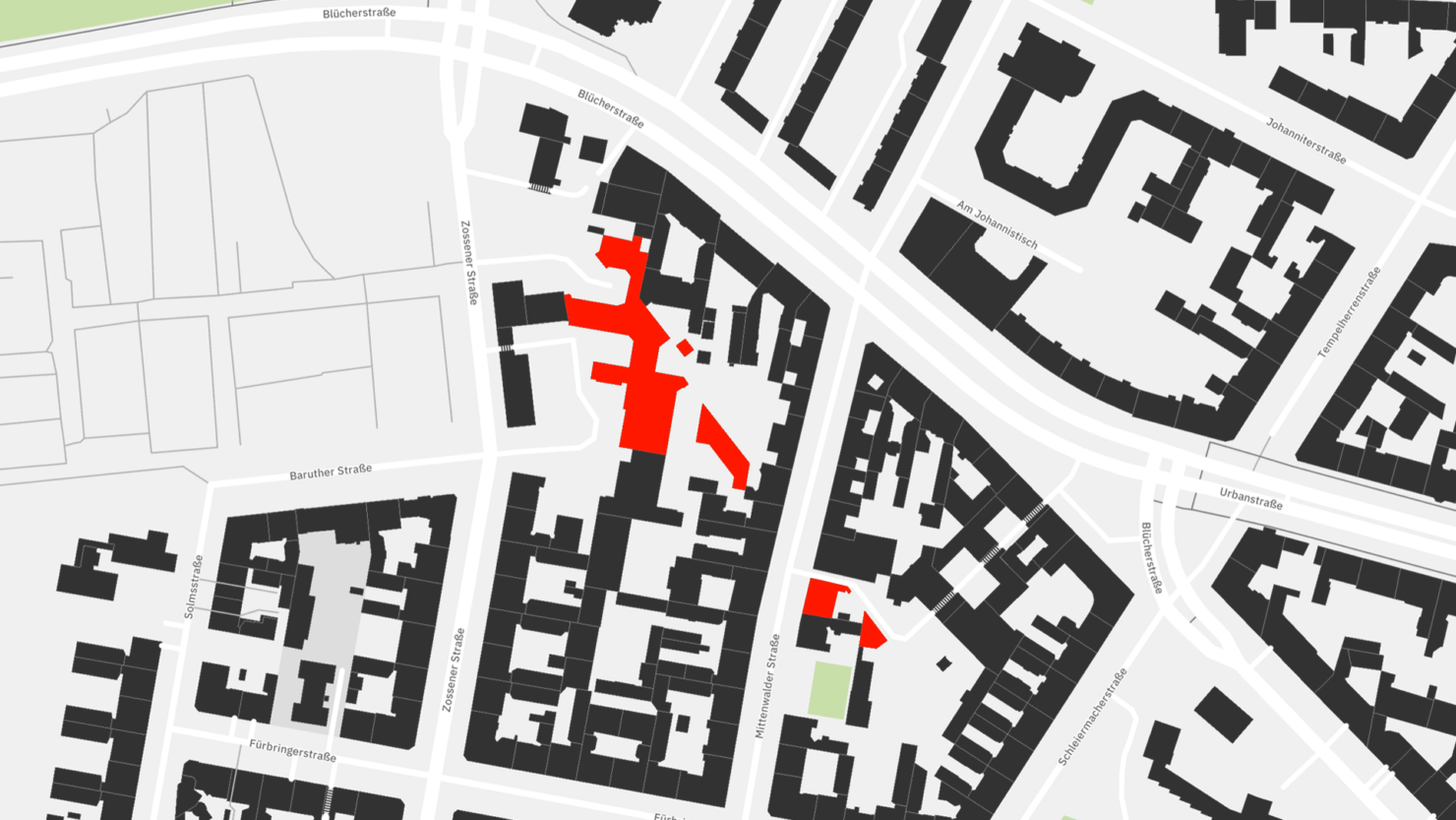
The discovery is that the diagonal I had first noticed expressed as an aberrant exterior wall was actually just a short section of a longer line which forms the hypotenuse of a large triangle embedded in the courtyards of two city blocks. The line doesn’t actually exist: like a stitch which has long dissolved into the tissues of the city, it is only legible by reading the surrounding buildings. The spectral diagonal and its triangular host needed to be inspected first-hand.
Bearing
I go exploring. I creep into courtyards, push up against bins and lean over railings, camera poised. The diagonal is already there, waiting for me, expressed first as a gnarly old chainlink-wire fence topped out with barbed wire. The fence, marking the property boundary of Blücherstraße 11, leads right up to the incongruous diagonal wall.

I walk to the northern tip of Zossener Straße, turn right onto Blücherstraße, and go hunting for back yards. The doors to Blücherstraße 13 are shut. Residents, visitors and postal workers might gain entry, but not a snooping detective of peculiar angles. I might have randomly buzzed the intercom and gained entry. How would the tale of a lost diagonal have gone down with the occupant? There is no need to find out, since the courtyard doors to Blücherstraße 14 are open. A rarity. I stroll in, but foresee access becoming an issue as I progress from yard to yard.
The courtyard is not what I expected. It’s long and very narrow. Narrower, in fact, than the apartment building itself, a feat achieved by the fact that the building is oriented along the diagonal of Blücherstraße, whilst the yard points south. The building itself is a postwar construction, occupying just the front of the property, and has no wings projecting into the rear as is typical for apartments built in the first few years of the 20th century. The upper four floors have odd little balconies which hug the firewall of the neighboring building like limpets clinging to a rock. Two rows of garages run down either side of the yard which at the end broadens out like the blade of a scalpel.
Even when I’m staring directly at it, the diagonal is not so easily made out. As though caught in the rotating mirrors of a rusting kaleidoscope, it is briefly marked by a fence (more barbed wire) and a long wall of heavily weathered brick, up which ivy creeps. Thereafter is slips out of view, engulfed by a disorienting confluence of obtuse and rectilinear boundary walls. The courtyard at Blücherstraße 15, one building further down, is sadly shut tight.
The configuration of buildings is typical of Berlin’s central districts where more-or-less orthogonal grids of early 20th-century building stock have been shoehorned into a web of criss-crossing medieval paths and causeways. So is the case here, where a regular grid of properties plods northward from Gneisenaustraße until it bumps up against the skewed drift of Blücherstraße where the wonky plans of apartment buildings are forced to reconcile the two. But nestled within all of this, like a concealed pleat, is the spectral diagonal, its presence acknowledged only by arrangements of bricks, an echo stripped of its sound-source.
Caillois’ Phantoms
Before I continue with the physical exploration of the diagonal’s ghostly passage, it’s worth making a minor detour to a brief and relatively obscure work of French literature. I’m referring to Roger Caillois’ Petit guide du XVème arrondissement à l’usage des fantômes, published in 1977 by Fata Morgana. The work was translated to English by Ryan Ruby and published by Amanda DeMarco’s sadly defunct Readux Books in 2015.
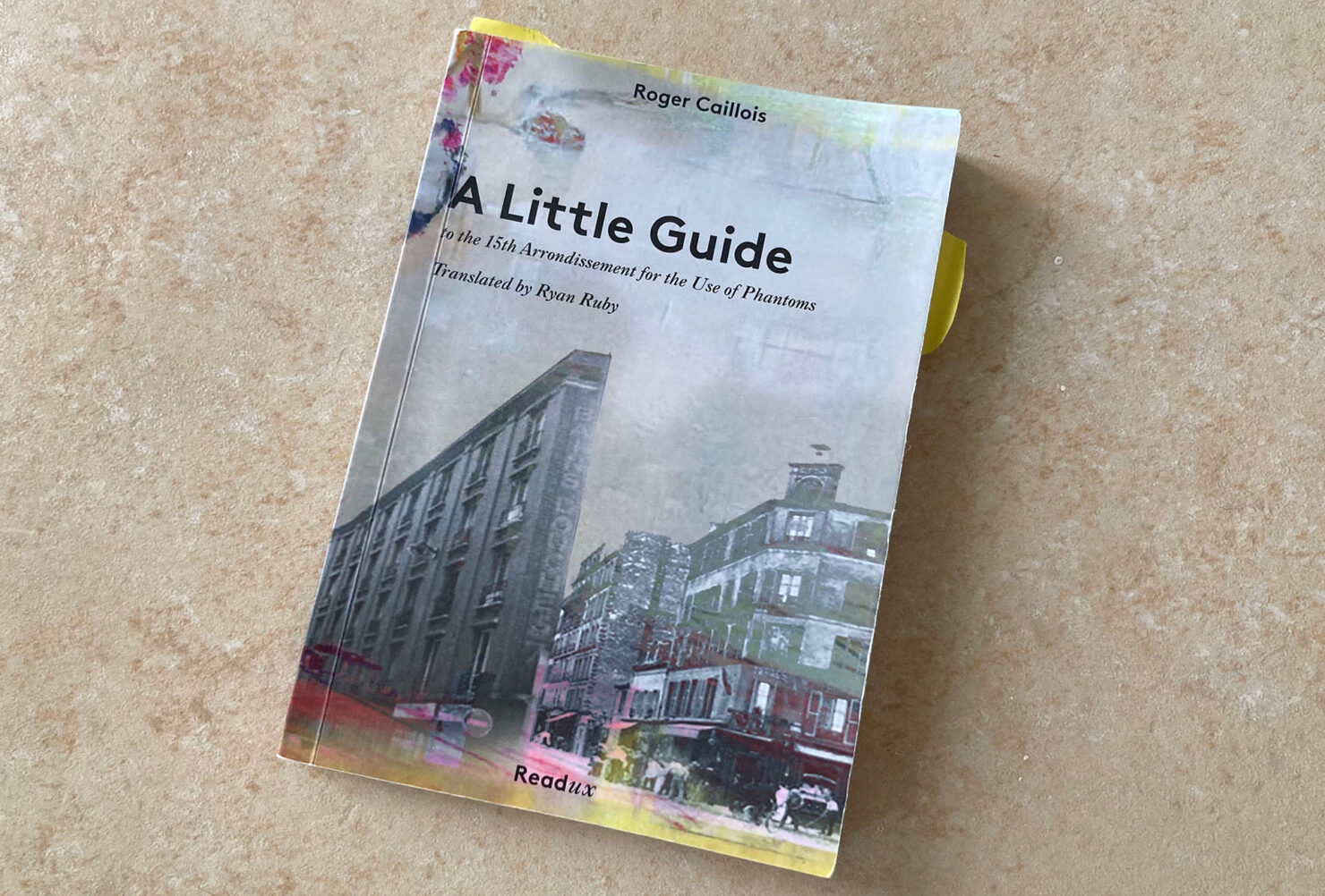
My serendipitous discovery of Caillois’ text several months after the diagonal wall, provided me with the crutch of justification for this whole exploration. It’s a beguiling work. Caillois was born in 1913 in Rheims. A literary critic, a philosopher of science, a novelist and sociologist (who later expanded on play theory), Caillois was initially associated with the surrealists until he fell out with André Breton during a “disagreement about the nature of the Mexican jumping bean”. I wish the short biography at the back of the publication could have expanded on this anecdote, but space was lacking, as is probably the historical record.
A Little Guide begins with an account of Caillois’ regular walks around his neighborhood, the fifteenth arrondissement of Paris, formerly the village of Grenelle. As with myself, the walking stimulates a heightened mode of noticing. Caillois “ends up examining the buildings that, for want of window displays … could present less obvious, that is to say less voluntary, objects of interest.” Uncannily mirroring my own experience with the diagonal wall, he “discovered buildings of a most common appearance, which nonetheless revealed unexpected characteristics upon closer examination.” I am comforted to find written precedent for what must appear a somewhat lonely and peculiar pursuit.
It’s during one of his walks that Caillois begins to imagine that some of the more dilapidated structures might serve as shelters for “the downtrodden”, or for traveling apprentices, who might lodge in them without fear of persecution. His imagination wonders to The Drug, a fantastical story by Léon-Paul Fargue which concerns “floating beings from some unknown Limbo” who congregate, unseen, in far-flung corners of the city. When finally noticed by a sharp-eyed individual, they are chased to the point of exhaustion, at which point the beings “fade, become transparent, sink into the earth, rise into the air like a balloon …” or “otherwise flatten themselves against a porous wall that absorbs them like blotting paper”.
The image is chilling. I’d like to see it filmed by Jordan Peele, Denis Villeneuve or Ari Aster. It must have given Caillois the chills too; so much so that the idea haunts him on future walks, and he begins to pursue these “untruthful creatures” himself and believe that his nondescript buildings are somehow naturally allocated to them. Crossing Avenue de Suffren, he encounters the first building of the fifteenth arrondissement on the corner of Rue de Suffren:
“The house leans sideways and doesn’t abut the next one. Forming a pronounced acute angle, it juts out awkwardly, so that, from a certain perspective, it doesn’t seem thick enough to give anyone shelter.” [my emphasis]
Furthermore:
“A profile just as thin, sometimes crenellated by toothing-stones, rises in the sky without anything leaning against it or fitting into it. The corner is left in limbo, forming a beveled edge so narrow that it must have discouraged architects from constructing the complementary building.”
Similar curiosities are to be found throughout the 15th Arrondissement, all symptoms of the oblique pockets of land formed by criss-crossing diagonal thoroughfares. Not far from the oddly stunted Rue de Soudan (cut short by Rue de Pondichéry), Caillaois peers through the bay windows of the Dupleix school complex and sees the playground beyond, which he is dismayed to find is dominated by an immense, neglected wall of “insidious hostility”. The sinister house to which the wall belonged, “presented the fateful cutaway, the strange sharp edge that seemed inhabitable only by the flat, immaterial beings, just as in the story by Fargue.”
Elsewhere, at the end of Villa Letellier, a cul-de-sac and private road, Caillois discovers a house, lower than the others, with a ruined lockless door, perpetually closed shutters and missing a street number. He notices that the awning above the central window of the top floor “hangs from a cracked wall”, and abruptly declares that the “house doesn’t exist”. Caillois realises that it is a dummy house, applied to the rear wall of another building.
Whether to avoid handing the wall over to advertisers, or to forego the cost and effort involved in growing vines up the wall, for Caillois’ already overactive imagination “the chosen solution almost definitely calls to mind a trap.” The “fluid beings” that squat in the city might be lured here, and, fooled by the building’s inviting thinness, become trapped inside like rats.
Slicing
For Caillois, the act of noticing becomes an act of play: the play of his imagination. As a sociologist he is widely cited in the field of ludology, or game studies, building critically on the work of Huizinger’s Homo Ludens, questioning its emphasis on competition. Finding it difficult to clearly define play, though, he comes up with six characteristics which might define it, one of which is that “it involves imagined realities that may be set against ‘real life’”.
Imagined realities set against real life: a neat summary of this publication’s slow pursuit of meaning in the built environment. Stood opposite the apartment building at Mittenwalder Straße 3, I gaze up at its stuccoed façade and silvery windows, and imagine the rooms inside bisected by a gelatinous shimmer which passes through walls, floors and ceilings, but bathtubs too, bookshelves, sofas, wardrobes, jars of pasta and children’s toy boxes. The shimmer, imperceivable in bright sunlight, might be visible within, but only at certain times of the day, and from a certain fleeting angle, not even as a general phenomena of light passing through air, but as a precise vertical agitation of airborne dust or a hair-thin thermal disturbance clinging weblike to the extremities of objects. Exiting the building, it ducks down, feeling its way through denser materials and slinks invisibly across the street where it grazes another exposed exterior wall, then the boundary of a tiny garden, then the blank rear wall of a low building, following the course of a service road which connects a post-war parking garage on Mittenwalder Straße with the two interior courtyards of the grand Jugendstil building at Blücherstraße 22.
But I’m getting ahead of myself, imagined realities momentarily more potent than the subtle geometries of this corner of Kreuzberg. The doors to Mittenwalder Straße 3 are shut tight, so a different view of the crumbling, vine-covered wall I had previously seen is sadly out of bounds. But next door, at number 4, a van has pulled up and two men are unloading tool boxes through the open doors. I follow them inside, through the dark interior hallway and into the tiny yard beyond.
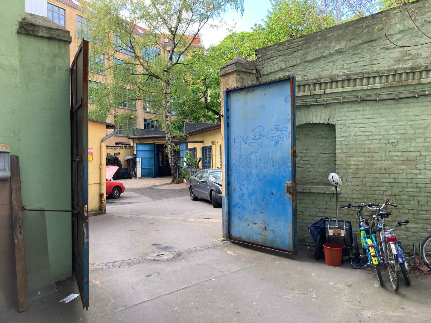
At the rear of the moss-green courtyard, two metal gates, blue and rusted and swung wide open, afford me a view of KiezGarage24 GmbH, a car glass fitter slotted into a wedge-shaped plot beyond. The low building on the right is the front side of the dilapidated vine-covered wall previously seen in the yard of Blücherstraße 14. A business like this is quite a find these days: mechanical, blue collar, essential: a throwback to the industrialised interior courtyards yards at the dawn of last century.
One of the mechanics asks if he can help. By way of explanation I offer that I’m looking for a property boundary, which seems to satisfy him, or at the very least, leads to no further questions. It always feels illicit, entering Berlin’s courtyards uninvited, though an open door is encouragement enough, and my intentions are benign I’m sure.
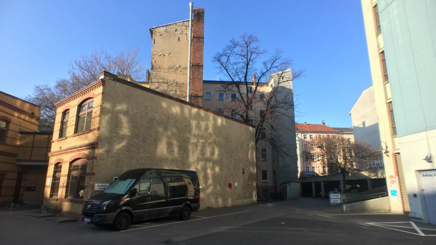
Across the road I enter the courtyards of the next city block, the one to the east, below Blücherstraße, enclosed on the eastern edge by Schleiermacherstraße. These yards are particularly rich in abutting land parcels. Seven plots coalesce here, though I don’t yet know this on the ground. I enter by way of a narrow lane and walk up to the upper deck of the parking garage which occupies the Mittenwalder 58 address.
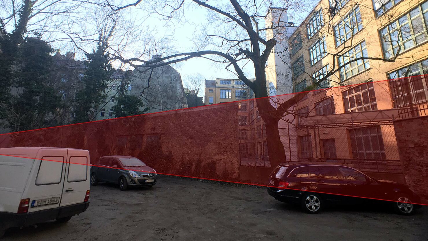
Peering down from the deck, I see that the diagonal line is picked up by a green painted wall. Though not quite the same shade as the moss coloured yard on the other side of the road, it’s a joyful symmetry nonetheless. Perhaps suggestive of the faint forces at play along the line.
Further into the courtyard, the first obvious sign of the diagonal expressed at ground level can to be found in the form of a shallow rainwater channel, which, doesn’t appear to mark the line per se, but runs parallel to it.
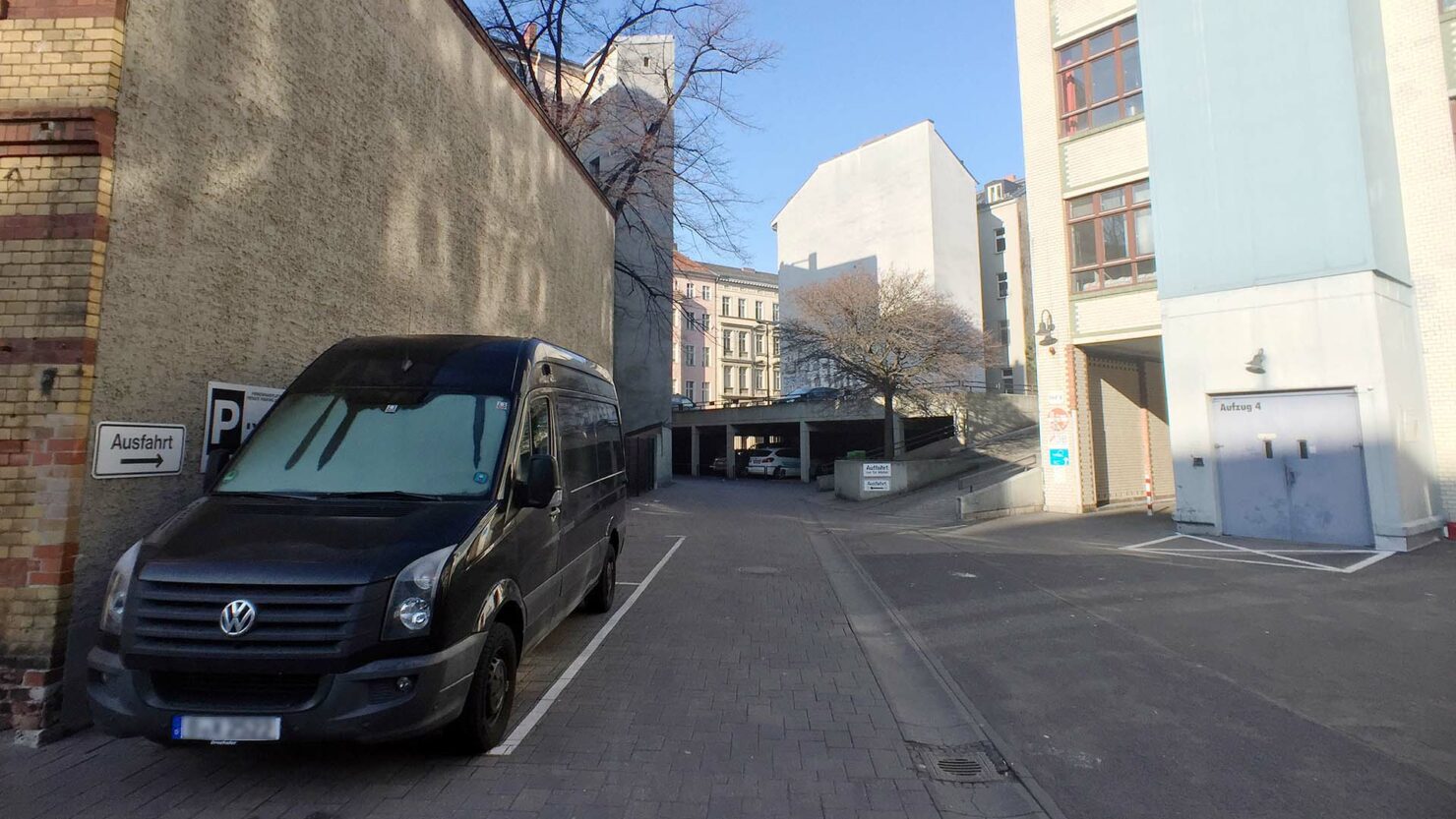
The space between the two, where the van is parked in the above 2019 image, feels in retrospect as if it might be a parcel in itself, which is confirmed by the Berlin Senate’s land registry map. In the views below I’ve marked in red all the land parcels which define the yard. Individual parcels are outlined blue.
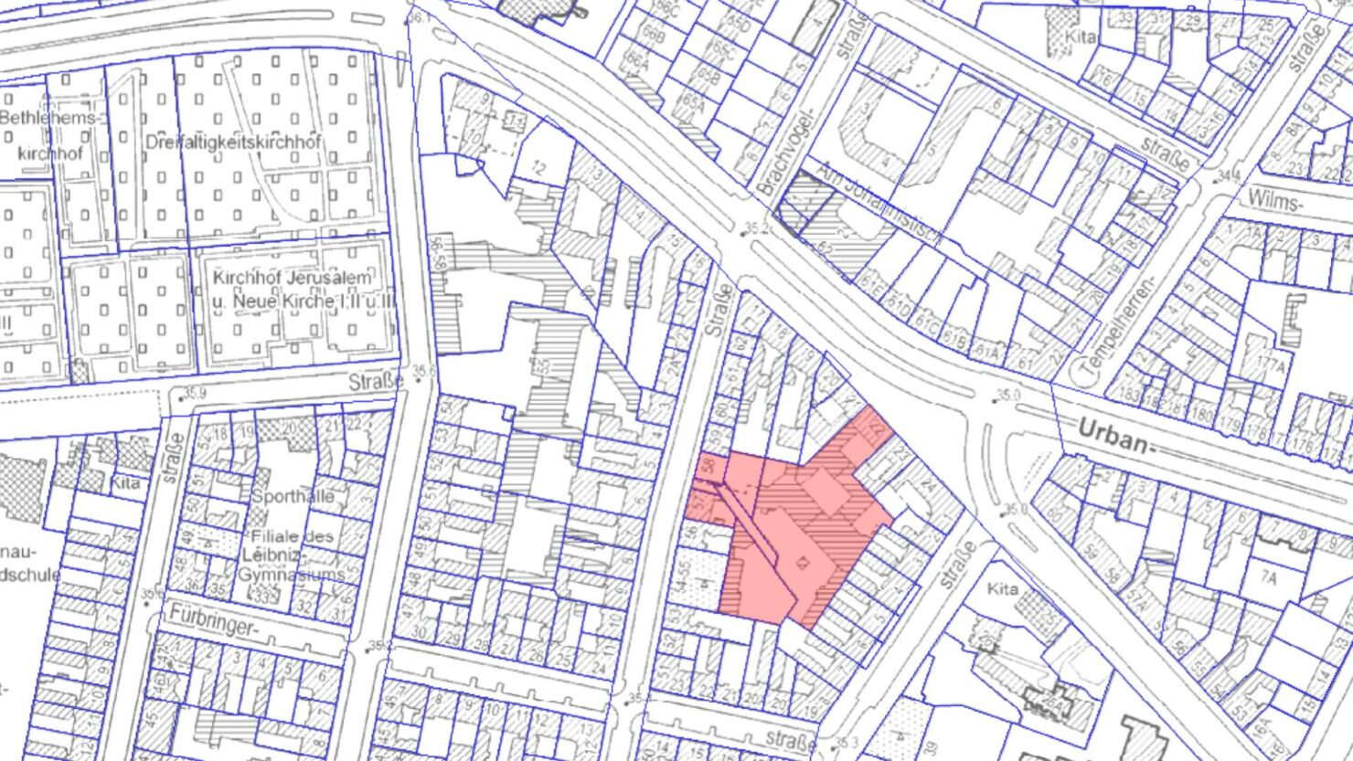
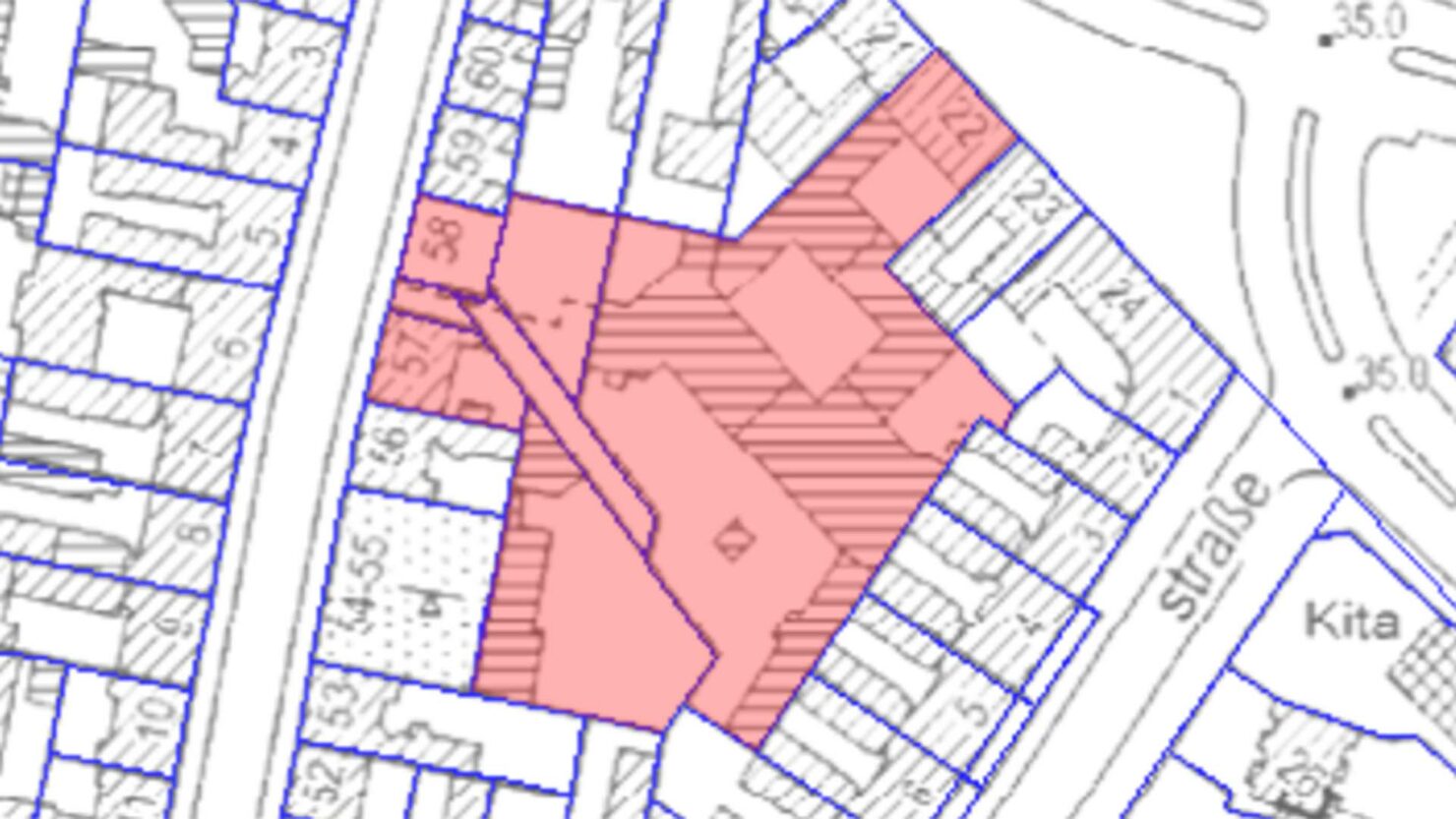
Our diagonal can clearly be seen running through its southern section, and the sliver of land is also marked, locked within the surrounding parcels. It seems to be a bizarre anomaly, but it is officially catalogued with the land parcel number 2465/204, and zoned as a “building for public use”, which implies the same status as a back yard. It is unbuilt and un-developable, surrounded on all sides by other plots of land, a corridor built purposely along the enigmatic diagonal, visible on the ground as a stretch of asphalt between a boundary wall and a gutter.
Emanating
Thinking of the line as a corridor, and seeing it so apparent on the ground is revealing. Looking back at the land registry map, it’s much more obvious that the diagonal I have pursued is not a single line, but a pair of them, and that the hidden parcel of land is key to understanding this:
The wall which instigated this investigation aligns with the upper line, as does the gutter in the yard behind Mittenwalder and the exterior wall pictured in the yard at Blücherstraße 13. The rear wall of the car glass fitter, observed behind Blücherstraße 14 aligns with the lower of the two lines, as does the green wall I noted whilst standing on the top deck of the parking garage.
A pair of parallel lines: a corridor, a pathway, a proto-road, buried away within the very material of the neighborhood, a structure so fundamental, so primal, that its echos can still be felt, not only in brick, concrete and asphalt, but in the municipal bureaucracy of ownership records and property contracts, in the notarized ink and frozen electrons of filed title deeds.
A forgotten old track, but one which has partially endured. There must have been countless which were less resilient to the march of industrialisation and the parcelling of land by 19th century property developers. When a pathway is too seldom trodden it withers away and grow over, just as our capacity to notice new things dwindles when routine dominates our habits. Routine is the opposite: a path trodden so often that it solidifies and makes other routes, other courses of action, seem impossible.
For the moment, investigation on the ground is complete. The line dissolves in the south-east corner of the Blücherstraße 22 courtyard where nothing physical indicates its presence. We must turn to old maps.
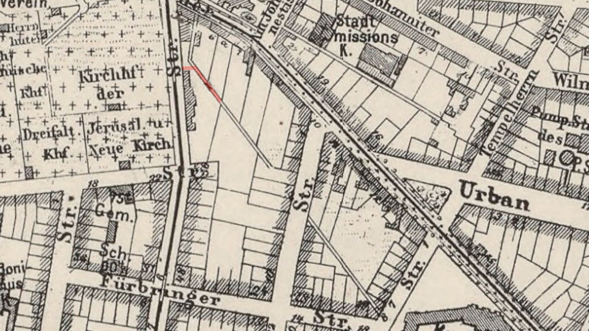
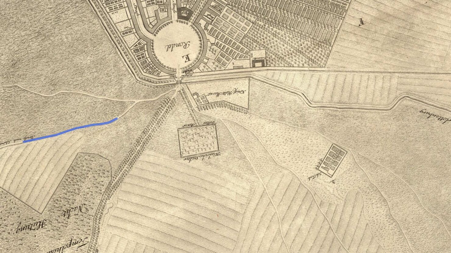
The earliest plan of Berlin I currently know of which adequately covers our site of investigation, is Samuel von Schmettau’s 1750 Plan de la Ville de Berlin, a copperplate engraved by Georg Friedrich Schmidt. North is at the bottom of this map, so Hallesches Tor is visible in the top-right panel, just above the Rondel, the distinctive circular plaza which sits just inside the city wall:
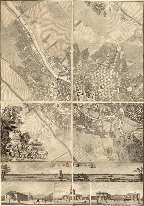
Let take a closer look at the area under investigation:
Now let’s re-orientate the map so that north is at the top:
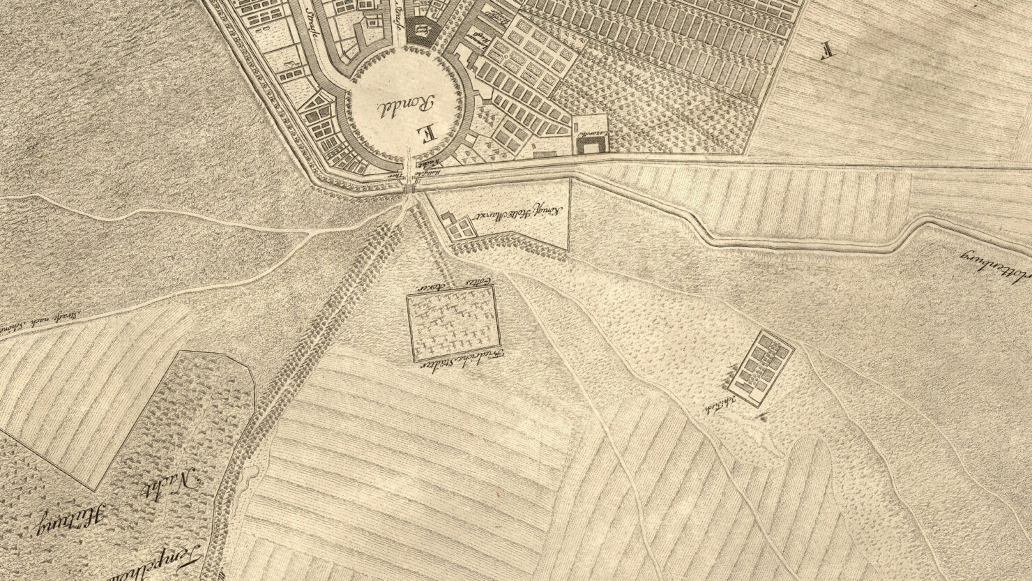
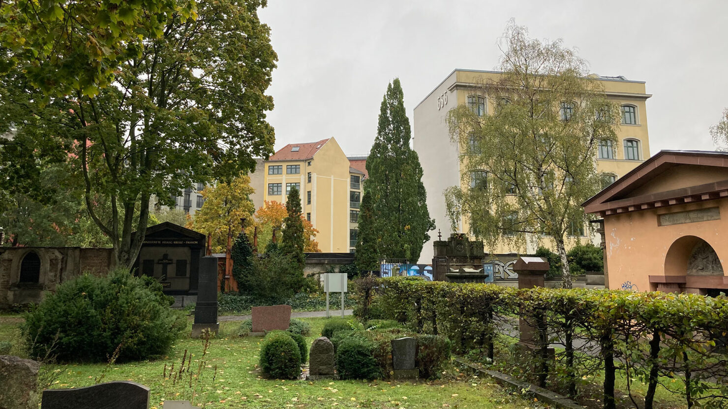
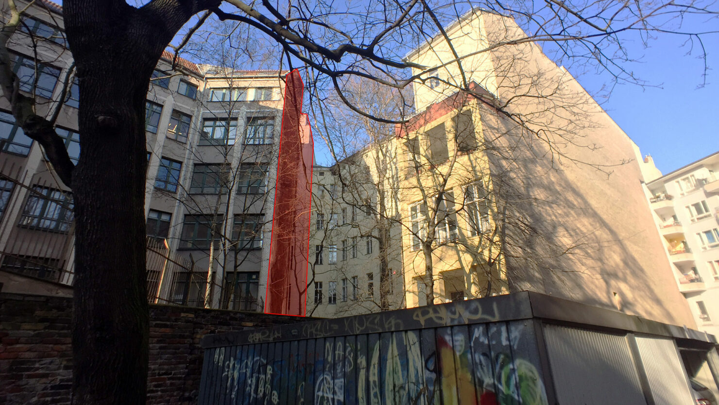
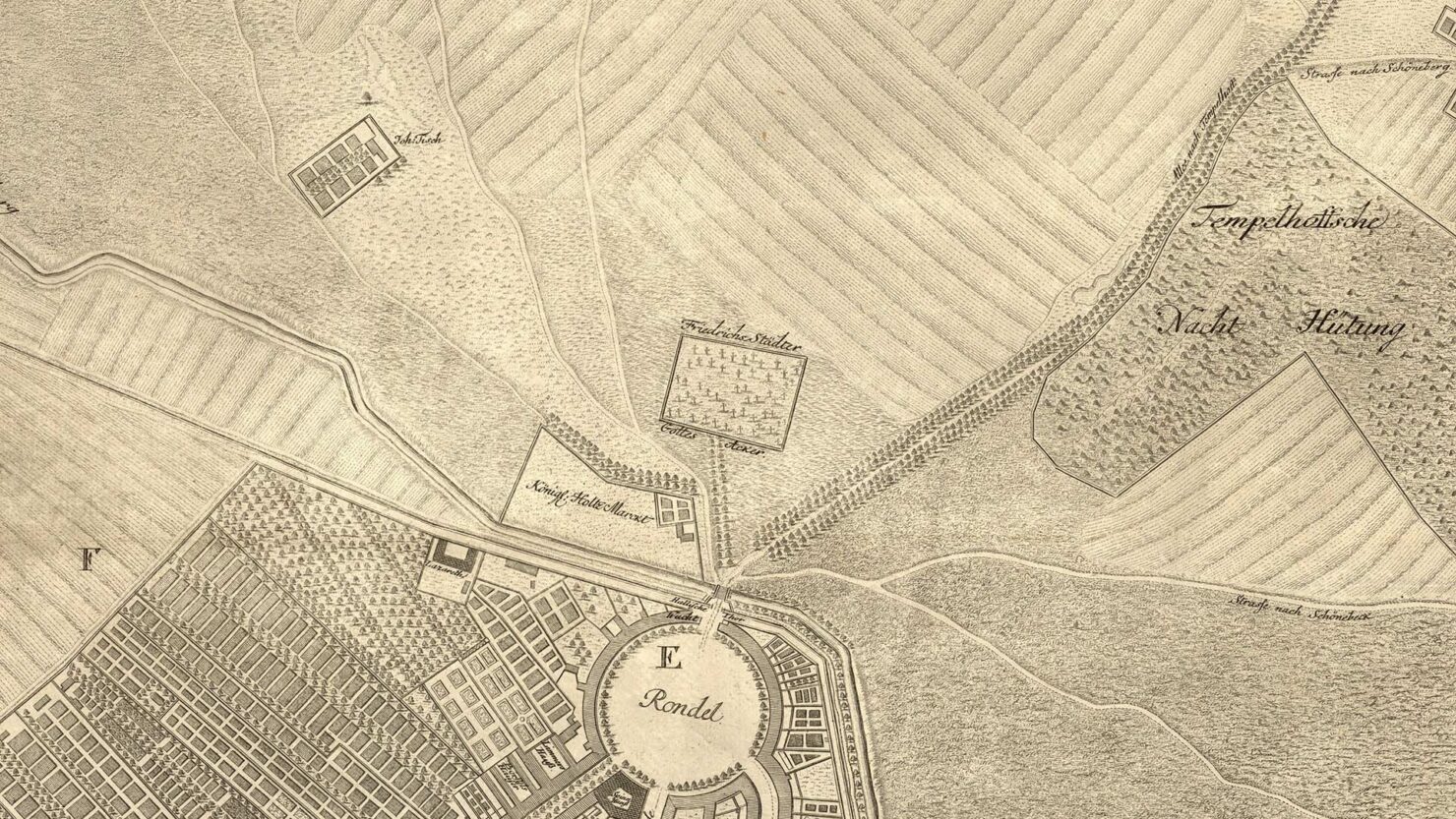
Just below the Rondel we have the old city gate, Hallesches Tor, or the Halle Gate, named for the city of Halle in Saxony-Anhalt, 50km to the south-west. The city wall runs east-west, but can be seen bending off north at the top-left, towards Potsdamer Platz. Parallel to it runs a ditch (the “Floss Graben nach Charlottenburg”), which later became the Landwehr Canal. The cemetary from where I took the second photo in this article is in the center of the image, and just to the right of it two tracks (we cannot yet call them streets) branch off to the south-east.
Perhaps the lower of the two is what I have discovered running through the yards. Let’s zoom back in and overlay Schmettau onto the Senate land registry map:
It’s possibly a fit. The alignment isn’t perfect, but then again neither was 18th century cartography, nor my Photoshop skills. We can expect some deviation from the contemporary plan, with the mis-orientation of the cemetery being particularly noticeable. But another landmark, the ensemble of buildings surrounding a garden at the top right, align almost perfectly with three contemporary land parcels. Abbreviated to “Joh:tisch” on the Schmettau map, this had long been accommodation for farm workers when the Johanniter Order presided over arable land stretching from here till Tempelhof much further south. A cul-de-sac called “Am Johannistisch” still leads to the plot of land, likely located at Johanniterstraße 7–9. When scaled correspondingly, the course of Blücherstraße snaps into place, as does our diagonal, which is clearly a field path.
A century later, in 1849, the situation on the ground has changed dramatically, and so has cartographic representation. This is a beautifully executed map by Ferdinand Boehm. We are still outside a walled city, beyond the Halle Gate, but the upper of the two tracks is now an established thoroughfare marked by trees, and has been called Pionier Straße, the street of pioneers. Forty years later it will be called Blücher Straße, named for a Prussian military man.
This map casts a bit of doubt over my theory: another path branches away from the lower corner of the cemetery, and a short track connects it to the edge of the fields. Deviations in the course of a path are to be expected in a 100-year period. So perhaps my path-theory is only partially correct, though the enigmatic diagonal, and the oblique triangle to which it belongs, is vividly rendered in the green ink of this chromolithographic print. It’s now easy to imagine how an uninterrupted amble along the line might have felt 170 years ago, with the open fields of the Johanniter Order to one side, and the garden fences of newly sub-divided plots of private land on the other.
But things were now changing rapidly in Berlin. In 1871, the same year that Berlin became capital of a unified Germany, and Wilhelm I became emperor, the Sineck Ground Plan was published. It documents not only what Berlin was at the time, but also what it was to become. Like the effluence which openly ran down its stinking streets, the city was about to spill out beyond its gates, with new suburban districts, and presumably a modern sewer system, already on the drawing board. Some field paths were to become permanent roads, others stamped out entirely.
The path has been reinstated by Sineck, so perhaps I was correct after-all. It has also become a proto-road, picked-out in beige, and the vague scattering of buildings in their garden plots have become more ordered, more precisely located, and have shifted towards the road.
By 1882, Sineck’s map shows more than just the intention of an urbanised neighbourhood. Streets are in place, a school and hospital too, and a tramline runs down Blücherstraße. Whilst the individual plots of land within the new city blocks are certainly not yet built up (my apartment building was constructed in 1903), Berlin’s characteristic block perimeters are already so important that they warrant an additional red line. But despite all this, the diagonal still persists as a property boundary, and perhaps still as a functioning pathway. The map captures a hybrid temporal state: the past and the future of Berlin frozen together in a whole, containing the two without contradiction. The root of the incongruous diagonal emerges out the duality represented by this map.
By 1905, the pathway is already about to dissolve, and the anomalies I’ve documented are beginning to emerge: the site of the slanting wall (which, curiously, seems to be marked by a thickened line); the skewed car-mechanics yard behind Mittenwalder Straße 4; and the isolated sliver of land with the parcel number 2465/204.
Distributing
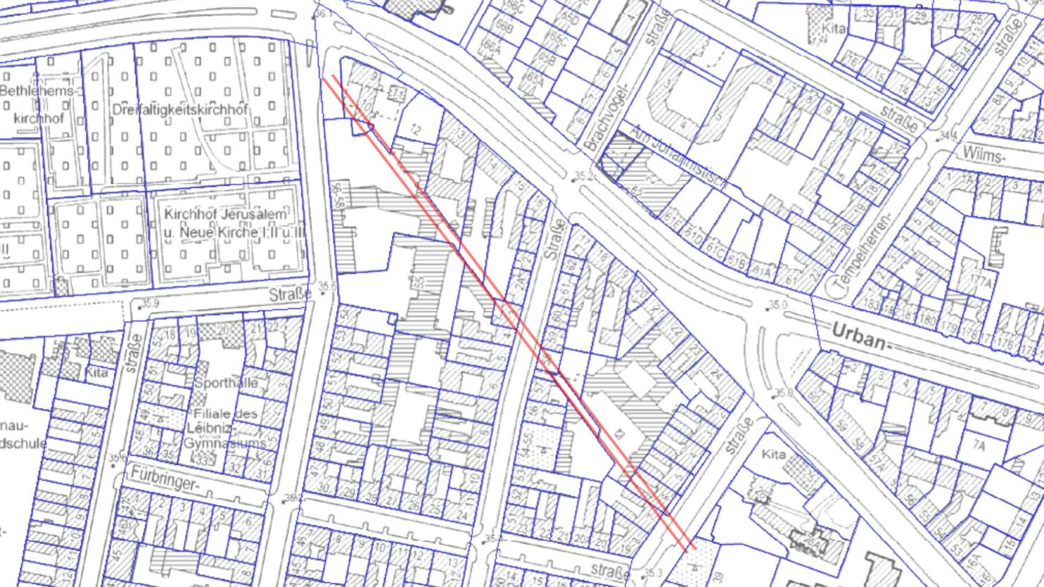
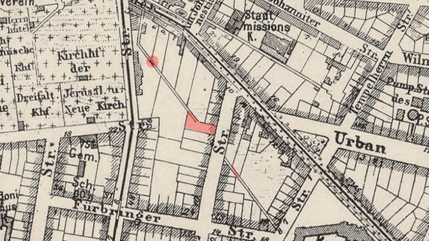
Where else is there to go from here? The anomalies are largely accounted for by a 200-year-old field path and the emergence of suburban real-estate in the mid 19th century. But my feeling is that a more abstract story of human behaviour can be told if we zoom out a bit and take a look at how our site of investigation relates to the old city gate, Hallesches Tor. And at the beginning of the article I mentioned a second feature of my immediate environment which volunteered itself for scrutiny.
Here’s an overview of the area south of Hallesches Tor:
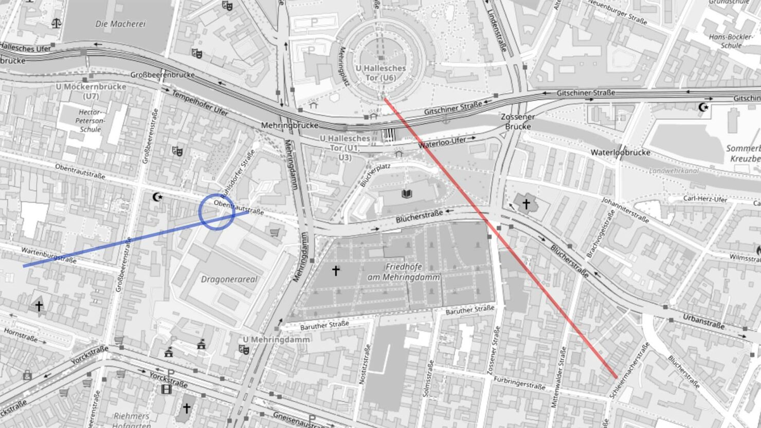
The diagonal investigated so far is marked with a red line, and I’ve extended the line towards the site of the old city gate. The correlation is so exact that I’m thrilled by the act of marking it. A field path once lead from the city gate, and headed southeast towards a large farmyard marked at the top of Schmettau’s 1750 map as “Rupperts Garten”. So we might call our phantom line Ruppert’s Way.
The blue line marks the orientation of a similar peculiarity of my immediate environment. The circle marks the location depicted in the following image:
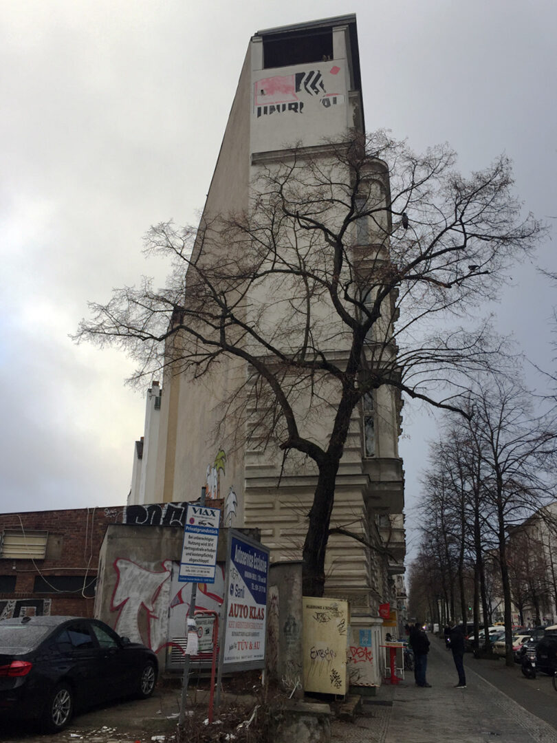
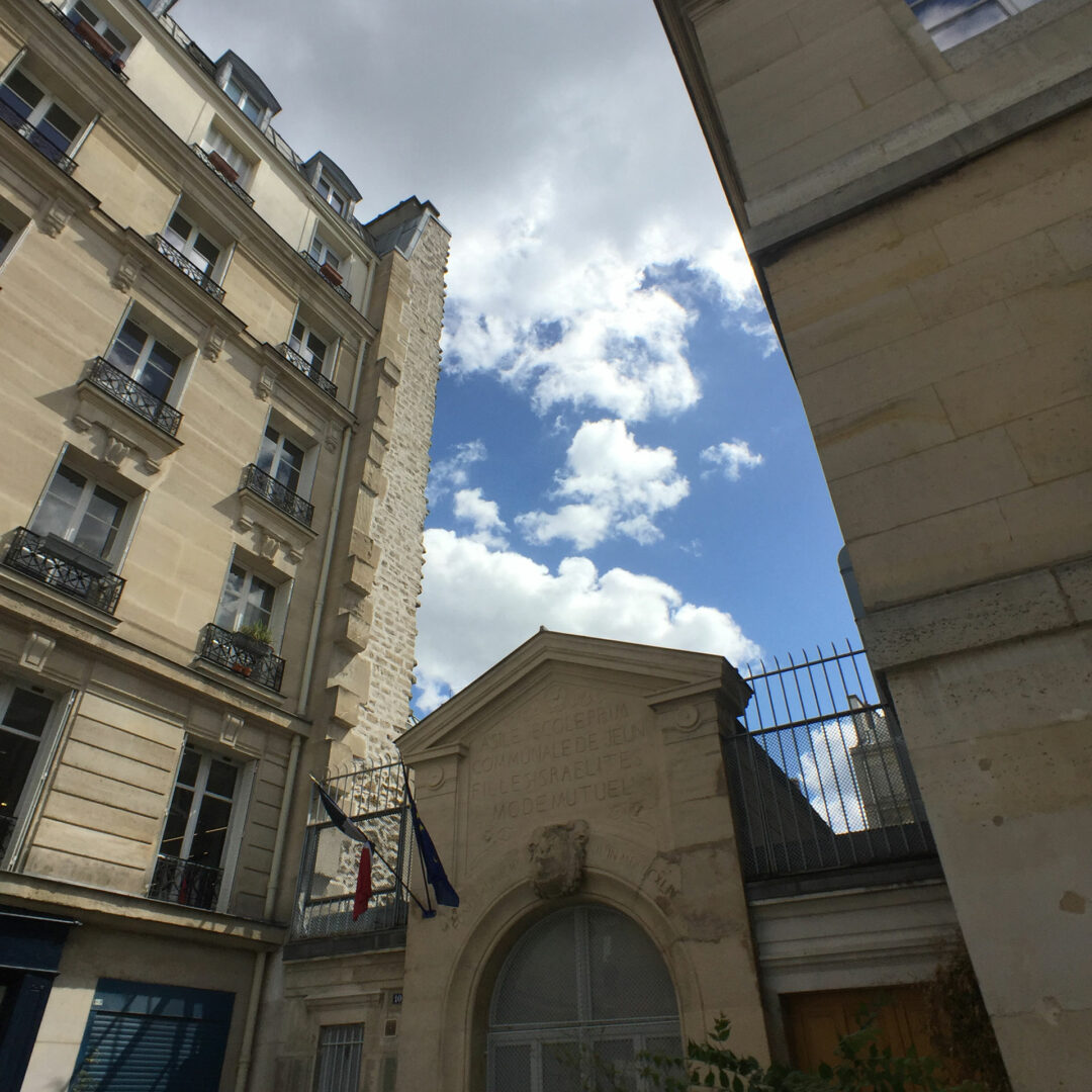
This is the ridiculously slim eastern façade of the property at Obentrautstraße 23. Why build like this? The rear wall is also windowless, anticipating an abutting development which was also never realised. Garages stretch along the full length of this wall, and the land parcel is so obtuse that it contains only a minuscule courtyard. In 2003, whilst apartment hunting with my wife, I briefly viewed a property here. It was an immediate reject: I remember the long, dark windowless corridor that lead to a wedge-shaped room with a bay window. The living room looked impossible to furnish.
The blue line, which marks the rear of this building, was also a field track. Land parcels would have been established beside it whilst it was still in use. Here it is on Schmettau’s map, where it is labelled “Strasse nach Schönebeck”, or Road to Schöneberg, the district and former village to the west.
Both forgotten paths, and hence the spatial anomalies in my neighbourhood, represent the fastest way by foot, or by horse and cart, between the city gate and two distinct locations: a village to the southwest and a farm to the southeast. They reaffirm the city gate as a point of entry, but also as a point of dispersal. The flow-lines of human and animal footfall, as marked on the 1750 map, seem fluid, almost as though the Rondel were a kind of nozzle: and of course, a gate is a kind of valve, a point where flow is regulated. Until 1812, Hallesches Tor was, for example, the only gate in southern Berlin through which Jews were permitted to pass upon registration.
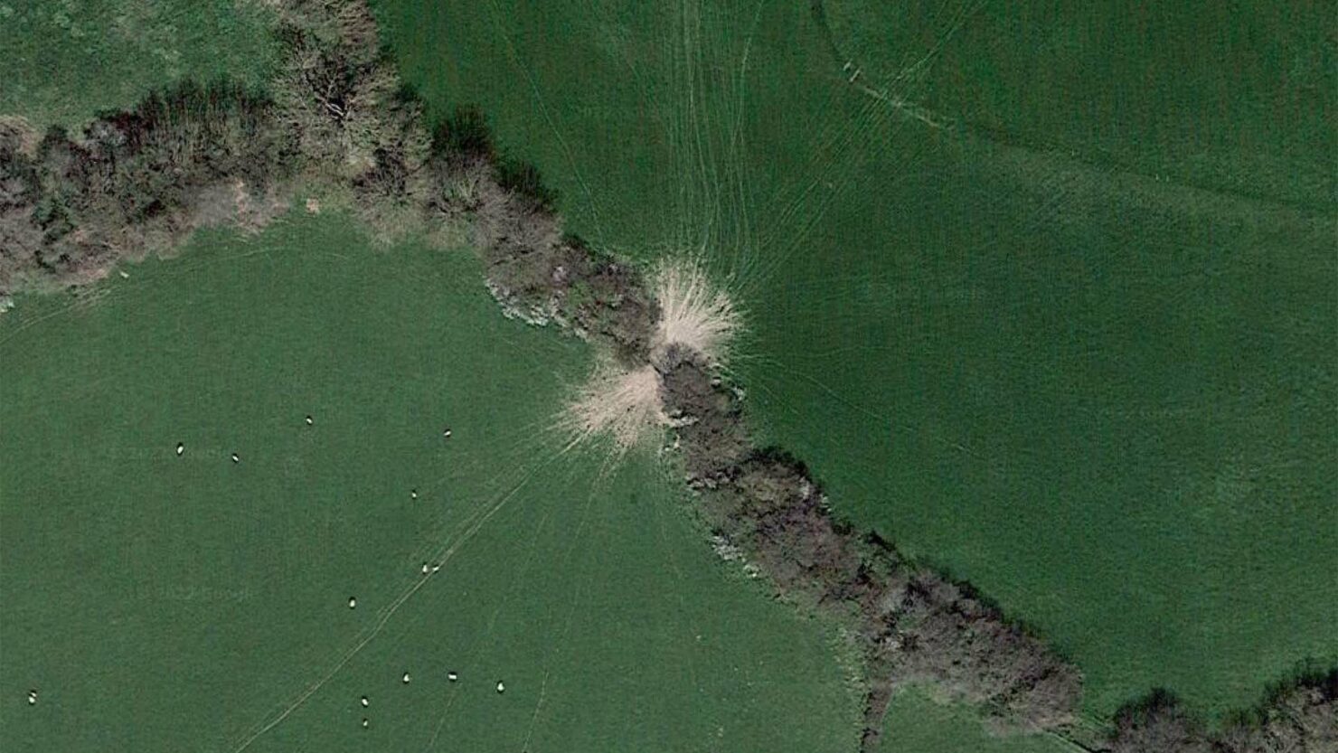
The contemporary city contains an imprint of its rural past, of fields and gates and tracks. Unrelatedly, I recently find myself scanning the Welsh countryside, looking perhaps for the picturesque villages of Clwyd: day-trip destinations of childhood holidays. And I notice something; something rather beautiful, visible only to the steady eye of downward pointing satellite cameras. Field boundaries, centuries older than Berlin and perhaps more ancient than that, and the trampled movements of animals drawing their own dispersal diagrams either side of a gate between two fields.
Postscript
It’s worth mentioning that, in an ironic twist of historic fate, the temporary access road which has been built to funnel cars into the courtyards behind the construction site at Zossener Straße 56, has inadvertently re-opened the old field path. The area in question is marked below on Sineck’s 1905 map. Though the temporary deviation is likely to close up once building work is completed, it shows that there is something very special, perhaps even powerful, about this pathway’s ability to endure.